
Switzer Falls and Bear Canyon Hike – 2017_0326
OUTING PHOTOS – At the Troop 718 Shutterfly Page – if you don’t have access, just request from the home page.
OUTING INFO
TOPO MAP WITH MILE MARKERS
 Loading...
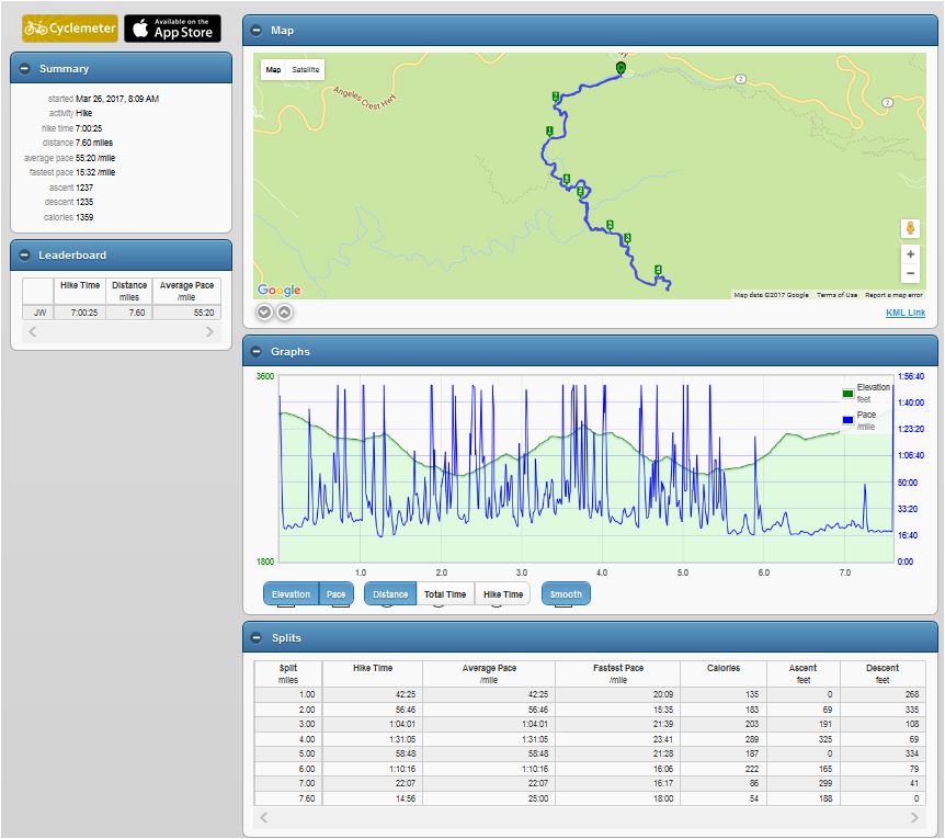
ACTUAL HIKE STATS (below)
To view in Hike Stats in Full Screen Browser – CLICK HERE
- Hikers who did the round trip and Switzer Falls – approx. 7.5 miles Total
- Hikers who did go to Switzer Falls – approx. 7.1 miles Total
The hike stats below accurately track the route traveled on this hike. However since the GPS tracking was locked onto the location of my phone only, the distance traveled is a little longer, as I traveled back and forth along the trail several times.
In any case, you all did a great job – thanks for your participation. If we could ask one huge favor of you… Please take a minute to scroll to the bottom of this webpage and enter a comment about this hike.
Your input will help us to better plan future events and it will be saved for future reference for others
- What did you like?
- What could make it better?
- Too hard, too easy?
- Favorite part?
Thanks again!
Sincerely, ASM Wakimoto, Outing Leader
CLICK ON THE IMAGE BELOW TO VIEW – FULL (INTERACTIVE) HIKE STATS


It was a cool hike